Kispiox Mountain
The Hazelton Property (the “Property”) comprises 74 contiguous mineral claims with a total area of 71,878.83 hectares located at NTS 93M centered at -127° 10' 46" Longitude, 55° 11' 5" Latitude (Figure 1). The Hazelton Property hosts seven projects: Red Springs, Blunt Mountain, Max, Netalzul Mountain, Mt Thoen, Rocher Deboule Mountain, and Kispiox Mountain. The Kispiox project consists of four contiguous mineral claims (Table 1) with a total area of 2,833 hectares at the northwest corner of the Property.
Exploration work was conducted on the Kispiox project in the summer of 2021, including prospecting, and rock and soil sampling programs. While prospecting the area, three quartz-sulfide veining mineralization zones were observed by Jaxon’s field team. The mineralization is characterized by significant amounts of stibnite, minor chalcopyrite and molybdenite. 54 rock samples and 11 soil samples were collected which returned significant antimony, copper, and molybdenum anomalies.
Antimony (Sb) is listed as a critical and strategic mineral by Canada and the United States and is utilized in the manufacturing of:
- Military applications such as weapons, communication equipment, military clothing and supplies
- High-tech applications including semi-conductors, circuit boards, electric switches, fluorescent lighting, high quality clear glass and lithium-ion batteries
- Green energy applications such as solar panels, wind farms and the next generation of liquid metal batteries
For more information on antimony:
Antimony Prices, Charts and News, Argus Media
Antimony: The Most Important Mineral You Never Heard Of , David Blackmon for Forbes.com
An Antimony Primer, Molten Metals, 2021
Canada's Critical Minerals List 2021 , Natural Resources Canada
Critical mineral resources of the United States—Economic and environmental geology and prospects for future supply, USGS List of Critical Minerals
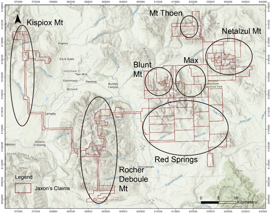
Figure 1. Kispiox Mountain Project on the Hazelton Property
Table 1. Property Claims Information
| Title Number | Claim Name | Issue Date | Good To Date | Status | Area (ha) | Projects |
|---|---|---|---|---|---|---|
1080197 | KISPIOX MT | 2020/DEC/23 | 2021/DEC/23 | PROTECTED | 1803.1173 | Kispiox Mt |
1080603 | KISPIOX MT 2 | 2021/JAN/16 | 2022/JAN/16 | GOOD | 368.083 | Kispiox Mt |
1083041 | KISPIOX WEST | 2021/JUN/11 | 2022/JUN/11 | GOOD | 275.7311 | Kispiox Mt |
1083042 | KISPIOX EAST | 2021/JUN/11 | 2022/JUN/11 | GOOD | 386.0591 | Kispiox Mt |
Geological setting
The Kispiox project is underlain by a series of sedimentary strata of the Late Jurassic Bowser Lake Group and Low Cretaceous Kitsuns Creek Formation of Skeena Group, intruded by numerous Late Cretaceous porphyritic intrusions of Bulkley Plutonic Suite (Figure 2).
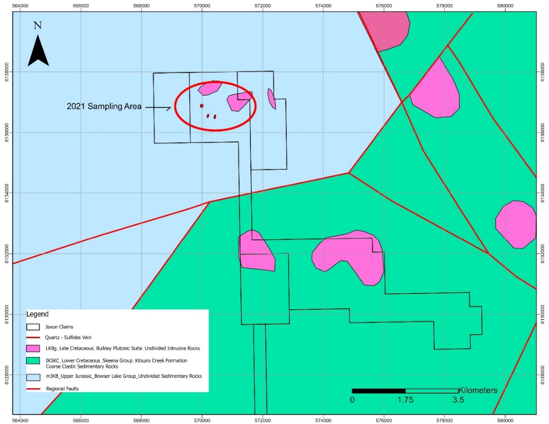
Figure 2. Geological map of the Kispiox project.
The Bowser Lake Group consists of interbedded epiclastic feldspathic and volcanic conglomerate, sandstone, siltstone, shale and argillite, minor coal, and carbonaceous units (Maclntyre et al., 1994). The Kitsuns Creek Formation of Skeena Group contain mainly feldspathic and volcanic sandstone, siltstone, shale, polymictic volcaniclastic conglomerate, coal, carbonaceous sediments (Maclntyre et al., 1994).
The Bulkley intrusive rocks include undifferentiated granitic rocks, equigranular to porphyritic granodiorite, quartz diorite, minor andesite, felsite, aplite, alaskite and intrusive breccia, stocks, plugs, sills and dykes (Maclntyre et al., 1994). Most intrusive rocks are rusty and well-fractured. The porphyritic rocks consist of phenocrysts of plagioclase feldspar, hornblende, and biotite, which are in a very fine-grained light grey quartz-feldspathic groundmass. Most intrusive rocks occur as dykes and plugs, which are locally associated with Mo, Cu, and Sb mineralization.
The associated quartz-sulfides veins are centered on an area most abundant with intrusive rocks, and the veins are most prevalent along the margins of the intrusions and sheared contact zones (P.McCarter, 1981). A great amount of stibnite was observed in the veins, and trace amount of very fine-grained chalcopyrite and molybdenite were also noticed within and adjacent to the veins. The sulfides are mostly fine-grained and disseminated in the veins. Pyrite is common on the quartz veins, and as fracture coating in the hornfels.
The widespread rusty pyritic zone, intrusive dykes and plugs, mineralized quartz veins, and anomalous Cu, Mo, Sb rock geochemical values is evidence a porphyry-epithermal Sb-Cu-Mo system exists at the Kispiox project.
History
Limited historical work has been carried out at the Kispiox property with three MINFILE showings recorded: Date, Mo and Burdick Creek.
The Date showing is located on the southeast flank of Kispiox, 19 kilometres northwest of the town of Hazelton. The area is underlain by sedimentary rocks of Late Jurassic Bowser Lake Group, intruded by a small granodiorite body of the Late Cretaceous Bulkley intrusions. Exploration activities on the Date showing were due to anomalous molybdenum contents in silt samples and trace chalcopyrite observed in the field. In July 1981 and 1983, Noranda Exploration conducted geological and geochemical surveys on the Date showing area along top ridge of Kispiox Mountain and valley bottom of Date Creek. 195 soil samples and six rock samples were collected and analysed in 1981, and 18 rock samples were collected and assayed in 1983. Anomalous Au, Ag, Cu, Mo, Pb, Zn were found in various rock and soil samples. Due to the rugged nature of the terrain, the exploration work was limited to the two areas.
The Mo showing is located eight kilometres northwest of the town of Hazelton on the west slope of Hazelton Mountain. The area is underlain by a small intrusive granodiorite body of the Late Cretaceous Bulkley intrusions, which cuts sandstone, siltstone and shale of the Lower Cretaceous Kitsuns Creek Formation (Skeena Group). Noranda Exploration prospected this area from May to October of 1984. Several quartz veins containing significant minerals were observed. A sample from a 2.5 centimetre-wide quartz vein carrying arsenopyrite and sphalerite assayed 9.9 grams per tonne gold, 126.7 grams per tonne silver, 1.4 per cent zinc, 1.2 per cent lead and 2.4 per cent arsenic (Holden, 1984).
The Burdick Creek showing is located 12 kilometres southwest of the town of Hazelton. An unnamed lead-zinc occurrence (#245) is shown in Geological Survey of Canada Open File 2322, and the showing is documented as a vein or fracture-related occurrence hosted in the Lower Cretaceous Kitsuns Creek Formation, Skeena Group. No other information is available on the occurrence.
Exploration
The Kispiox project is characterized by isolated rugged mountain peaks separated by broad wooded valleys. Most of the exploration in 2021 was conducted above the tree line, an area characterized by rugged cliffs and steep talus slopes. As a result, geological and geochemical surveys were confined to accessible parts of the property. Several quartz-sulfide veins were outlined by Jaxon’s field geologists. These quartz veins zones contain significant amounts of stibnite, minor chalcopyrite and molybdenite (Figure 3).
Rock Samples
A total of 54 rock samples were collected from outcrops, including 33 mineralized rock samples and 21 geochemistry samples. The high-grade rock samples contain varied amounts of sulfides, such as stibnite, molybdenite, and chalcopyrite. The geochemistry samples were taken to collect the background value of each element.
The rock samples were analyzed by MSALABS in Langley, BC. Highlights include 11 samples with more than 1000 ppm antimony, including four samples with more than 1% antimony; seven samples with more than 500 ppm copper, including three samples with more than 1000 ppm copper; and three samples with more than 100 ppm molybdenum. Trace amounts of galena and sphalerite were observed in the granodiorite intrusive rocks where one sample returned 1047 ppm lead and 2003 ppm zinc.
Key Highlights of 2021 Rock and Soil Sampling Program at Kispiox Mountain Project:
- Three high-grade antimony sulfide quartz mineralization outcrops (KS zone 1, KS zone 2 and KS zone 3) were identified with the rock sampling program (Figure 3).
- A high-grade rock outcrop sample (A0027254) with up to 29.69% antimony was collected from within an 8-10 m wide sulfide quartz veining mineralization zone (KS zone 1) (Figure 4), which contains minerals of lead-gray stibnite and yellow valentinite. Four surface weathered outcrop samples (A0027255, A0027282-A0027284) assayed Sb grades from 0.18% to 0.59% (Figure 5, Table 1). The oxidation and weathering of the stibnite minerals on the surface may have reduced the antimony grade within the surface rock samples.
- Six meters of chip samples (A0027274-A0027276) (Figure 6) from the second sulfide quartz antimony mineralization zone (KS zone 2) reported an average of 2.52% antimony including two meters of a massive sulfide zone @ 6.48% antimony (Table 2, Figure 7) and four meters of multiple narrow sulfide antimony quartz veins from 1 centimeter to 20 centimeters wide.
- Three rock samples (A0027277-A0027279) were collected from KS zone 3 with Sb assays from 0.77% to 2.76% (Figure 3, Table 1), these rock samples contain typical striated prismatic stibnite crystals (Figure 8).
- 31 rock geochemical samples show elevated Cu, Mo, As, Sb anomalies (Table 3, Figure 9) and serve as classical signatures of a deeper porphyry system.
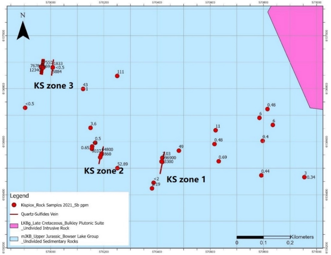
Figure 3. Three Sb sulfide quartz mineralization zones (KS zones 1, 2 and 3) at Kispiox Mountain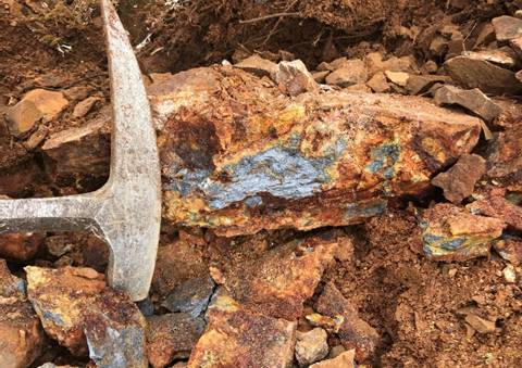
Figure 4. Up to 29.69% Sb rock sample with stibnite and valentinite from 8-10 metre-wide KS zone 1.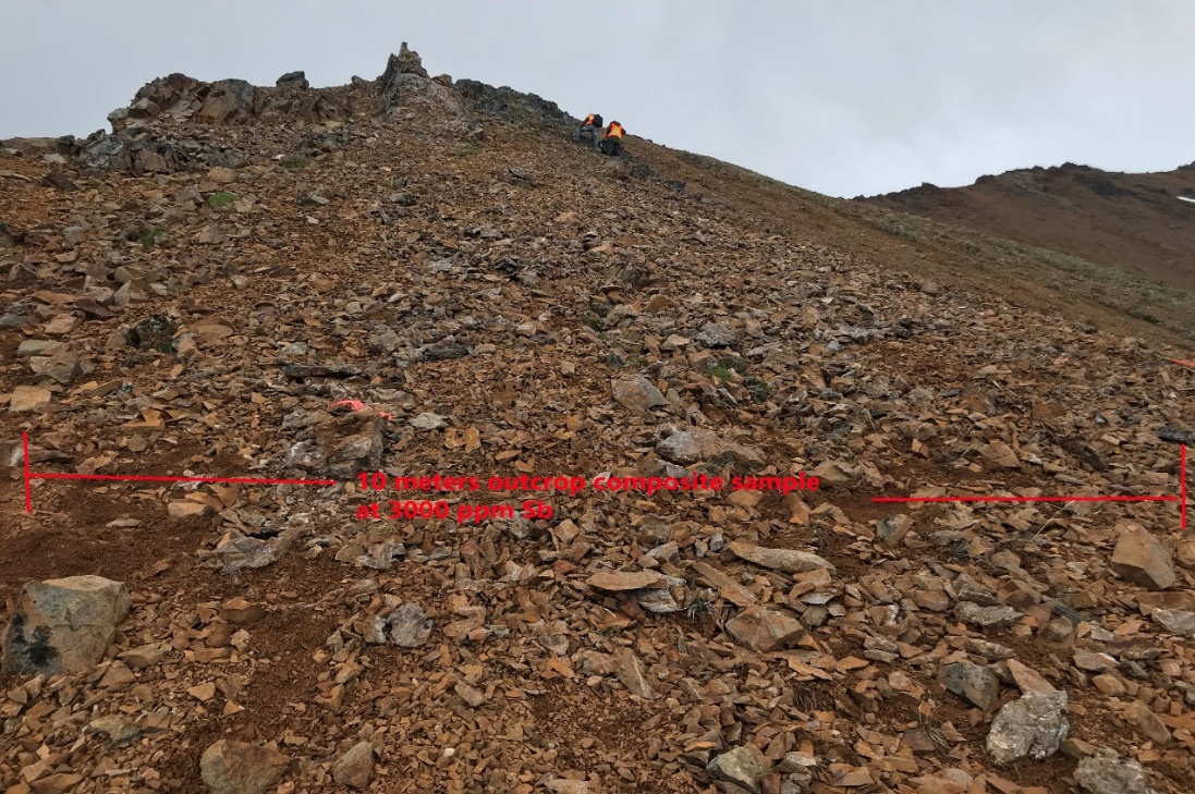
Figure 5. 8-10 metre-wide Sb quartz vein mineralization outcrop (KS zone 1).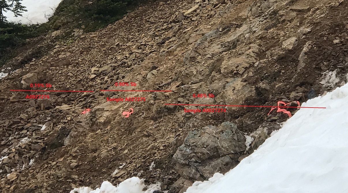
Figure 6. Six metres of chip samples from KS zone 2 outcrop.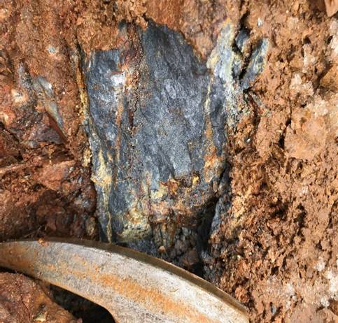
Figure 7. >2 metre-wide massive antimony sulfide (stibnite) at KS zone 2.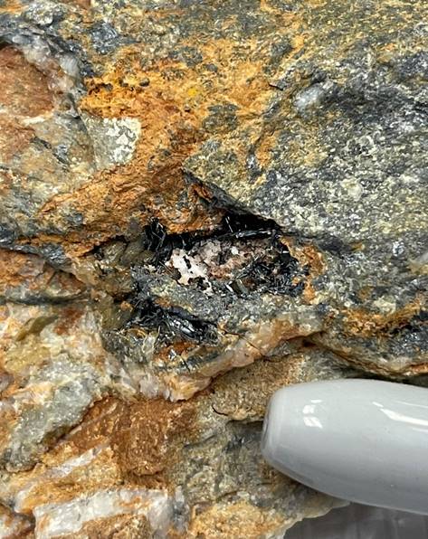
Figure 8. Antimony rock sample with typical striated prismatic stibnite crystals from KS zone 3.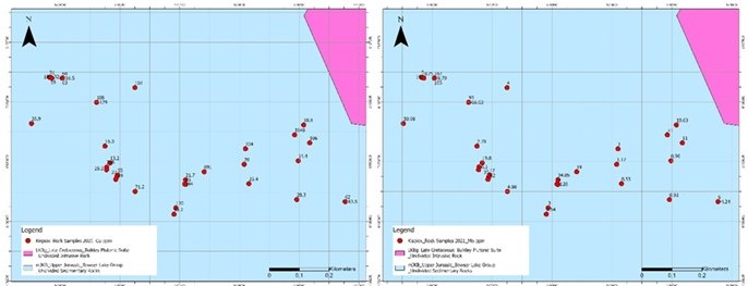
Figure 9. Strong Cu and Mo in rock anomalies.
Table 2. Significant Assay Results from Rock Samples at Kispiox Mountain Project
| Sample ID | Description | Ag ppm | Au ppm | Cu ppm | Pb ppm | Sb ppm | Zn ppm |
|---|---|---|---|---|---|---|---|
A0027254 | 10-15 cm wide vein, antimony, stibnite, massive sulfide | 0.7 | 0.02 | 95 | 68 | 296900 | 18 |
A0027255 | Composite sample, 10 m wide, hornfels with disseminated sulfides, mainly antimony | 1.1 | 0.03 | 94 | 13 | 3300 | 36 |
A0027274 | Silicified dacite dyke with quartz veins and stibnite veins, 2m chip sample. Str. fractured. The width of stibnite veins varies from 10cm to 0.5 mm. High grade, containing four wide stibnite veins, 10 cm, 3cm, <1cm, <1cm, and many stibnite veinlets | 0.5 | <0.01 | 55 | 41 | 64800 | 70 |
A0027275 | 2-meter chip sample, containing three stibnite veins, 5 cm, 3cm, <1cm, and many stibnite veinlets | 0.5 | <0.01 | 27 | 12 | 9037 | 37 |
A0027276 | 2-meter chip sample, containing one wide stibnite veins, 3cm, and many stibnite veinlets | 0.5 | <0.01 | 48 | 13 | 1860 | 75 |
A0027277 | Four parallel quartz-stibnite veins within 2 m width, Strike: 5°, Azimuth: 95°, Dip: 60~65 °. First vein 15 cm wide, 4-meter west of second vein | <0.5 | <0.005 | 31 | 77 | 27550 | 741 |
A0027278 | Second vein. 3~5 cm wide, 1.5 m west of third vein | <0.5 | <0.005 | 59 | 52 | 7678 | 114 |
A0027279 | Chip sample, including third vein and fourth vein. Third vein: 5 cm, Fourth vein: 10~15cm. Vein interval: 1.5 m. | <0.5 | <0.005 | 18 | 19 | 12340 | 55 |
A0027282 | Sb mineralization zone, 8 m wide composed sample with multiple 10-1 cm quartz-sb veins | 1.1 | 0.02 | 68 | 38 | 1833 | 46 |
A0027283 | <0.5 | 0.009 | 52 | 8 | 5884 | 38 | |
A0027284 | <0.5 | 0.022 | 63 | 25 | 1869 | 51 |
Table 3. Rock Geochemical Sample Assay Results
| Sample ID | Easting | Northing | Ag ppm | As ppm | Au ppm | Cu ppm | Mn ppm | Mo ppm | Pb ppm | Sb ppm | Zn ppm |
|---|---|---|---|---|---|---|---|---|---|---|---|
72451 | 570381 | 6136424 | 1.03 | 1.6 | 0.002 | 95.2 | 203 | 7.64 | 15.2 | 2.19 | 19 |
72452 | 570420 | 6136539 | 0.06 | 6 | <0.001 | 21.7 | 364 | 34.85 | 2.5 | 2.03 | 45 |
72453 | 570616 | 6136591 | <0.05 | 3.7 | <0.001 | 20 | 720 | 1.17 | 2.5 | 0.48 | 78 |
72454 | 570632 | 6136526 | <0.05 | 5.2 | <0.001 | 25.4 | 468 | 0.55 | 1.8 | 0.69 | 78 |
72455 | 570792 | 6136473 | 0.08 | 1.7 | 0.001 | 28.3 | 471 | 0.93 | 1.5 | 0.44 | 60 |
72456 | 570797 | 6136603 | <0.05 | 1.4 | <0.001 | 14.4 | 559 | 0.96 | 2 | 0.4 | 75 |
72457 | 570815 | 6136723 | <0.05 | 1 | <0.001 | 18.8 | 296 | 19.63 | 1.9 | 0.48 | 23 |
72458 | 569405 | 6136799 | 0.07 | 3.7 | <0.001 | 45.9 | 740 | 1.55 | 3.5 | 0.35 | 102 |
72459 | 569413 | 6136891 | 0.09 | 4.9 | <0.001 | 50.4 | 808 | 0.57 | 4.6 | 0.46 | 109 |
72461 | 569425 | 6137007 | <0.05 | 3.7 | 0.002 | 8.2 | 989 | 0.61 | 2.3 | 0.86 | 70 |
72462 | 569391 | 6137062 | 0.09 | 11.1 | <0.001 | 47.8 | 639 | 1.85 | 3.2 | 4.4 | 91 |
72463 | 569282 | 6137015 | 0.08 | 8.5 | <0.001 | 17.1 | 1415 | 0.77 | 4.7 | 0.37 | 80 |
72464 | 569262 | 6136913 | 0.05 | 5.3 | <0.001 | 25 | 1190 | 0.98 | 3.8 | 0.89 | 80 |
72465 | 570954 | 6136466 | 0.08 | 3.9 | 0.001 | 63.5 | 311 | 4.24 | 1.8 | 0.34 | 26 |
72466 | 570155 | 6136573 | 0.06 | 1.7 | <0.001 | 28.2 | 491 | 6.1 | 1.9 | 0.65 | 33 |
72467 | 570167 | 6136596 | <0.05 | 0.9 | <0.001 | 13.2 | 531 | 19.8 | 2 | 0.5 | 27 |
72468 | 570251 | 6136500 | 0.07 | 9.8 | <0.001 | 71.2 | 260 | 4.98 | 2 | 52.89 | 30 |
72478 | 569904 | 6136728 | 0.06 | 0.9 | <0.005 | 26.9 | 318 | 10.98 | 3.6 | <0.5 | 32 |
72479 | 570008 | 6136880 | 0.02 | <0.2 | 0.018 | 16.5 | 346 | 8.79 | 4.1 | <0.5 | 32 |
72480 | 570122 | 6136799 | 0.13 | 1.5 | 0.006 | 129 | 428 | 66.03 | 5.9 | 1 | 31 |
72481 | 570150 | 6136652 | 0.03 | 1.5 | <0.005 | 16.3 | 459 | 7.78 | 3.5 | 3.6 | 29 |
7460 | 569424 | 6136915 | 0.7 | 37 | 0.01 | 25 | 752 | 2 | 10 | 4 | 73 |
Soil Samples
A total of 11 soil samples were collected by Jaxon’s field crew. Most soil samples were located adjacent to KS zone 1 and zone 2 stibnite mineralization. These soil samples were analyzed with an Olympus Handheld Vanta XRF analyzer. The data fromthe soil samples used to delineate the anomalies are listed in Table 4 below. Antimony values are displayed on Figure 9.
Key Highlights of the 2021 Soil Sampling Program at Kispiox Mountain Project:
- 11 soil samples were collected from an area between KS zone 1 and KS zone 2 and tested with a handheld XRF analyzer in the field, which confirmed high Sb in soil anomaly of up to 736 ppm (Figures 9).
- Five samples returned significant antimony values of more than 100 ppm, 10 samples returned copper value more than 100 ppm and five samples returned molybdenum values more than 100 ppm (Figures 9-10).
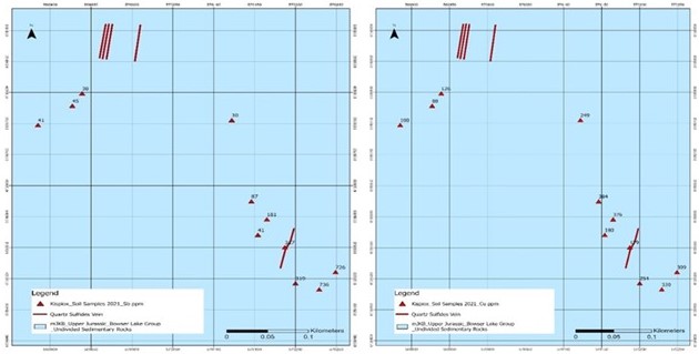
Figure 10. Soil samples with Sb (left) and Cu (right) values.
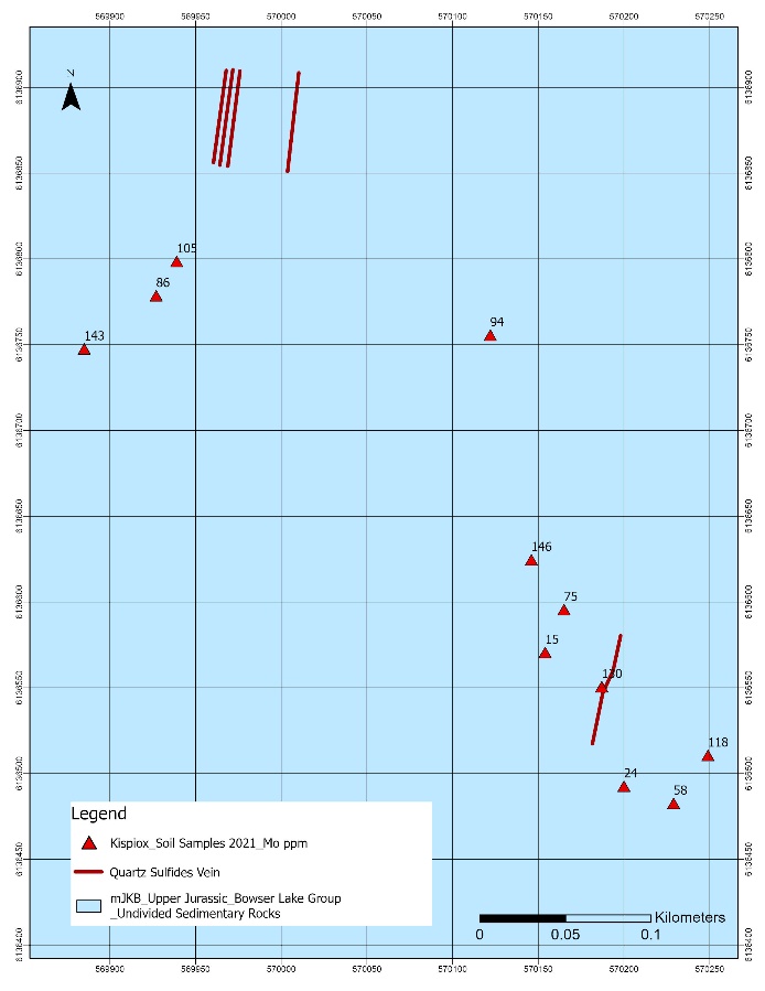
Figure 11. Soil samples with molybdenum values.
| Sample ID | Easting | Northing | Elevation | Sb ppm | Cu ppm | Mo ppm |
|---|---|---|---|---|---|---|
A0027918 | 569885 | 6136748 | 1588 | 41 | 100 | 143 |
A0027919 | 569927 | 6136779 | 1624 | 45 | 88 | 86 |
A0027920 | 569939 | 6136799 | 1632 | 38 | 126 | 105 |
A0027921 | 570122 | 6136756 | 1612 | 30 | 249 | 94 |
A0027922 | 570146 | 6136625 | 1579 | 87 | 384 | 146 |
A0028951 | 570154 | 6136571 | 1590 | 41 | 180 | 15 |
A0028952 | 570165 | 6136596 | 1602 | 181 | 376 | 75 |
A0028953 | 570187 | 6136551 | 1567 | 317 | 179 | 130 |
A0028954 | 570249 | 6136511 | 1547 | 726 | 309 | 118 |
A0028955 | 570229 | 6136483 | 1514 | 736 | 330 | 58 |
A0028956 | 570200 | 6136493 | 1519 | 319 | 254 | 24 |
Table 7. Assay Results from Four Soil Samples from Kispiox Mountain Project
Conclusion
The 2021 ground program at the Kispiox Mountain project focused on exploring the unique type of high-grade stibnite-rich polymetallic vein mineralization related to Bulkley intrusions. Three sulfide quartz-antimony vein mineralization zones were outlined. Rock and soil samples returned very high-grade stibnite and copper, molybdenum, lead and zinc anomalies. These are distal sulfide mineralization and are indicative of a porphyry system.
The high-grade antimony results confirm the pervasive nature of mineralization at Kispiox, potentially the largest antimony deposit in North America. A systematic soil and sulfide rock outcrop channel sampling program will be conducted in the summer of 2022. The elevated Cu, Mo, Pb. Zn, As elements in the strong oxide hornfels suggest a potential relation between the epithermal stibnite mineralization and a deep porphyry system.